In general, maps reveal the interests of their makers. The following maps provide varied representations of Hunter Island from the 17th Century to the present.
1. 1685 Dutch Settlement Map
By the mid 1600's Native Americans and Europeans were sharing the landscape. Hunter Island is likely one of the smaller islands clustered at the north western end of "Lange Eylandt" (Long Island). View Original Map
2. 1776 British Campaign Map
The British Army Campaign Map includes this sketch of Hunter Island. Purchased by Thomas Pell from the Siwonoy Indians in 1654, the island had already been in British hands for over 120 years. The oldest recorded settlement, occupied by Joshua Pell by 1743, is likely depicted here. View Original Map
3. 1858 Map of Westchester County
By mid 1800's nearby New York City had become a thriving metropolis and what was later to be the Bronx was the site of country homes and landed estates. Note the Roosevelt, Morris and Bartow family names on the mainland. The Hunter Mansion, built circa 1811, is located here at the island's center. View Original Map
4. 1868 Atlas of New York and Vicinity
In 1866, Hunter's heirs sold their island estate to Ambrose Kingsland, a former New York City mayor. This map reflects the change in ownership. Of this date the connecting bridge and road to Twin Island was yet to be built. View Original Map
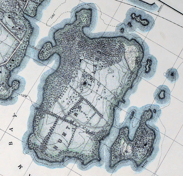
5. 1885 Topographical Map of Land to be Taken for Pelham Bay Park
In 1885 Hunter Island was still in private hands. This map displays a meticulously detailed rendering of the Hunter Mansion Gardens and landscape. The transition to Pelham Bay Park was complete by 1888 but neither the park nor the Bronx were yet a part of New York City. By 1895, however, all lands east of the Bronx River were incorporated into the city proper and city ownership of Hunter Island was realized. View Original Map6. 1905 Topographical Survey of the Bronx
7. 1920 Fisherman's Map of Hunter Island and Surrounding Waters

This map is helpful in establishing baseline depths for the surrounding waters of Long Island Sound. It is especially useful in light of the major landfill of the 1930's which obliterated Pelham Bay and damned the flow of salt water around the island's western shore. View Original Map
8. Modern Topographical Map
Modern topographical map showing major land elevations of Hunter Island from sea level to 80 + feet above mean high water. View Original Source9. Bedrock Geology:
From bedrock and engineering geologic maps of Bronx County and parts of New York and Queens Counties, New York. Red coloration represents the Hartland Formation (Middle Ordovician to Lower Cambrian), Pelham Bay Member. Purple coloration represents Amphibolite (Silurian to Middle Ordovician) Intrusives. Sg signifies intrusive Granite and Pegmatite. From the National Geologic Map Database. Source images here.
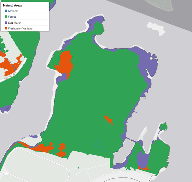
10. Map of Major Natural Divisions

Courtesy of the Natural Areas Conservancy Nature Map Archive. This map color codes four major natural divisions of Hunter Island: 1. Streams, 2. Forests, 3. Salt Marsh, and 4. Freshwater Wetland. Click here for more NYC Park Natural Area Maps.
11. Composite Overlay of 1905 Topographical Survey and Modern Satellite Imagery
This map, created by this author, clearly shows the geographical differences between Hunter Island before and after the 1930's landfills. The darker areas are original landmass and the center tan portions represent the Orchard Beach landfill. Most of Pelham Bay was filled to provide parking facilities. The crescent sandy beach was created with sand brought in from elsewhere. (This is an original image.)12. 1986 Natural Biology of Hunter Island
This unique map breaks down Hunter Island into small recognizable biological segments.. Click here for entire report and key to numerical tags.
13. Current USDA Soil Survey Map:
This map shows soil type and slope of Hunter Island. This information is keyed to the USDA Web Soil Survey website. Maps are available for the entire US. Click here for original source material.
14. Hike/Bike Trails
This trail map is courtesy of AllTrails.com. Hunter Trails are easily hiked and biking is allowed. View Source Map
For a Hiker's Guide to the Kazimiroff Nature Trail click here.


Comments
Post a Comment